Kununurra
Kununurra, in spite of all it’s apparent isolation, is an interesting modern town which came into existence in the early 1960s as a construction centre for the Ord River Scheme and the creation of the majestic Lake Argyle.
The eastern gateway to the Kimberley and the home of outback adventure, it has a population of approximately 6,000 people. It is well serviced with a modern hospital, leisure and aquatic centre, specialty shops, air and ground passenger services.
The construction companies and local council have created a modern town centre which boasts an excellent swimming pool-leisure centre complex, a substantial Commonwealth Bank, a delightful ‘traditional Australian’ broad verandahed Post Office and a number of large supermarkets.
Kununurra Accommodation
- Hotel Kununurra
- Hotel All Seasons Kununurra
- Kimberley Grande Kununurra
- Country Club Resort Kununurra
Kununurra Attractions
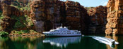
A feature of the town is the extensive waterways, which form the basis of the Ord Irrigation Scheme. The mighty Ord River, once a series of waterholes during dry season, is now a permanent waterway. From the Diversion Dam upstream to Lake Argyle, the Ord has developed into an intricate and interesting ecosystem of rivers, wetlands and lakes.
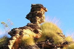 Surrounding the town itself is a variety of unique rock formations, which are typical of the region. The colours and shapes of these formations just have to be seen, like Mirima Nature Park, known locally as Hidden Valley.
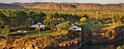
The town is the ideal base for an adventure holiday, utilising one of the many 4WD, cruise or flight operators located in Kununurra. From this one centre, visitors can access all parts of the Kimberley in a variety of fashions, limited only by time, preference and budget.
Popular destinations which can be reached from Kununurra include the Bungle Bungles, Lake Argyle, Gibb River Road, the Mitchell Plateau, the Ord River, Argyle Diamond Mine, plus many others.
A view of Kununurra from Kelly’s Knob
Crossing the Ord River
The Ord River is situated in the east Kimberley region of Western Australia and extends into north-western Northern Territory. It rises near Halls Creek and has a catchment area of some 64,000 km². It is approximately 650 km long and flows via Lake Argyle and the Kununurra Diversion Dam (Lake Kununurra) on route to the Cambridge Gulf near Wyndham.
 Towns
Towns Attractions
 Hotels